
Before the Big Dig: The Rise and Fall of Boston’s Central Artery
Today, Boston is a picturesque, bustling city where people navigate the historic streets by car, subway, bike, or on foot. But it hasn’t always been this easy to get around or this beautiful.
More than 75 years ago, as cars became affordable and popular, Bostonians realized their city was struggling to adapt to traffic. The curving, centuries-old streets built for horse-drawn carriages simply couldn't handle the automobile age. City planners needed a modern solution.
What they built in the 1950s was a massive, elevated highway known as the Central Artery. It was a major construction project that would transform Boston's transportation, but not for the better. For the next 50 years, this structure would cut through the heart of the city like a scar.
While Boston still faces plenty of traffic challenges today, our modern transit system is the result of lessons learned from the mid-century Central Artery debacle and is an infamous chapter in Boston history that eventually triggered the legendary "Big Dig."
The Walking City: How Bostonians Moved Before the Automobile

1903 depiction of the Tremont Street Subway Head House next to busy Tremont Street
Long before the highway arrived, Boston was a pioneer in modern public transportation. The first subway line, the Tremont Street Subway, opened in 1897, making it the very first subway in North America. Over the next two decades, rapid transit exploded across the city, including the continent's first underwater transit tunnel to East Boston in 1904.
By the 1920s, Boston was a highly efficient "walking city" supported by robust train lines and ferries. It was a well-thought-out system for the city's residents, since most people lived and worked within the city limits. The North End, South Boston, Charlestown, East Boston, Roxbury, and Dorchester all functioned as dense neighborhood communities where daily necessities were within walking distance.
The Car Popularity and the Breaking Point of Colonial Streets
Everything changed between the 1920s and 1940s. The success of the Ford Model T put automobiles everywhere, and the city's narrow, colonial layout was instantly overwhelmed. Streetcars still carried enormous numbers of passengers, commuter rail brought workers from outside the city, automobiles became increasingly common, and buses started replacing some trolley routes. There were simply too many people trying to access too narrow a road.
By 1945, the city was at a tipping point. If you stood in downtown Boston at the end of World War II, you would see a chaotic mix of streetcars clanging through intersections, elevated trains running overhead, crowded sidewalks, and an ever-growing gridlock of cars competing for zero parking.
The looming traffic crisis wasn't a failure of design; it was a failure of adaptation. Boston was attempting to force a massive wave of private car ownership onto historic streets that were never built to handle it.
City planners decided the only way forward was to build upward.


The "Highway to the Sky": Why the Central Artery Was Built
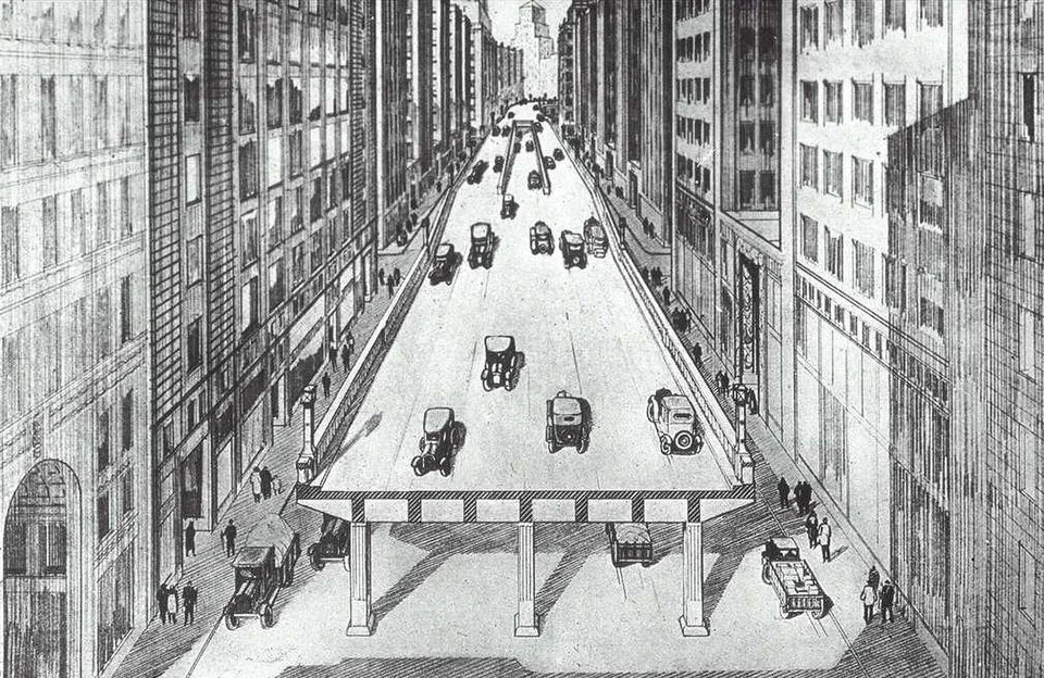
Between 1951 and 1954, the city built the elevated Central Artery dozens of feet above the streets, promising smoother trips in and out of downtown. Local media optimistically dubbed it the "Highway to the Sky." The overhead road was meant to make commuting easier, lift traffic away from the crowded streets below, and reduce noise and exhaust pollution.
The reality, however, was devastating. To make room for this "progressive engineering feat," the city demolished entire city blocks. The project displaced more than 1,000 buildings and uprooted roughly 20,000 residents and local business owners from their neighborhoods.
From Dream to "Distressway": The Destructive Reality of the Artery
Once the city began living with the Central Artery, the verdict was unanimously grim.
The elevated highway was loud, suffocatingly polluted, and visually oppressive. The heavy steel girders lifting this highway were painted the same green as Fenway Park's left-field wall. This ‘Green Monster’ was not beloved. Bostonians stopped calling it the Highway to the Sky and started calling it "The Distressway" and "the largest parking lot in the world."
This hulking elevated highway created a logistical and social nightmare:
Severe Overcrowding: By 1990, more than 200,000 vehicles a day crawled across a road originally designed to handle just 75,000.
Safety Hazards: Bumper-to-bumper congestion led to an accident rate roughly 4 times the national average.
Dividing the City: The highway’s shadow created dim, unsafe, and unwelcoming corridors below. It physically severed downtown Boston from its oldest neighborhood, the North End. The barrier was so severe that it wasn't until the 1976 Bicentennial tourism push that outsiders began to consistently brave the dark underpasses to explore the historic area.


The Road to the Big Dig: Planning a Way Out
By the 1980s, the consensus was clear: the Central Artery had to go. The city needed a plan that would restore traffic flow, erase the noise pollution, and give the city back to the people.
However, tearing down a city's main transit artery while keeping that city alive would require the most ambitious, expensive, and chaotic urban engineering project America had ever attempted.